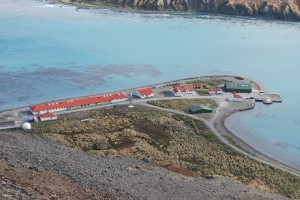
Aerial view of base
 This is a picture taken of base from Mt Duse on Sunday.
From left to right the buildings are as follows….
Larsen house – self catering accomodation (this year used for museum staff, rat eradication program, external science staff, building staff)
Sat B dome – put in by american project sending siesmic information to their program
Container next to the blue one (so red one) is the sauna
Building next to containers (short one) is the old jail which will be refitted for storage
Long building (from left to right) Shack villa (government officer accomodation self catering), accomodation for base staff, bar, dining room, kitchen, temperature control facility (aquarium), labs for scientists, offices, post office, conference room, communications room
Sat C dome on tower
First detached building after long building – Carse house – government officers accomodation self catering
L shape building – Discovery house – old labs – not in use and in need of renovation
Small red and white building between L shaped and green – food stores
Green building – boat shed, garage, garbage facilities, gym, carpenter shop, generators
Green building in foreground – fuel storage
Small square white building between two green – biosecurity building
Wharf with two jet boats tied up
One Response to “Aerial view of base”
-
mum and dad November 4th, 2010 at 10:56 am
Still shirt sleeve weather in G.B, shorts for you? x mum

